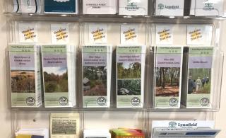
6 brochures downloadable here – and in print at the Library and Town Hall

The complete set of trail map brochures are now available for residents and visitors to Lynnfield’s Conservation Areas. All brochures can be downloaded below, and are in print version at the Lynnfield Library and at the temporary Town Hall office at 590 Rear Main Street.
The collection includes a general brochure titled “Open Space & Conservation Areas” which describes all trails and passive recreation parks in town. The remaining 5 trail map brochures detail the individual trail network areas; Beaver Dam Brook Reservation, Bow Ridge/Kallenberg Quarry, Partridge Island/Reedy Meadow, Pine Hill Conservation Area and Willis Woods.
Trail Map – Open Space & Conservation Areas
Trail Map – Beaver Dam Brook Reservation
Trail Map – Bow Ridge/Kallenberg Quarry
Trail Map – Partridge Island/Reedy Meadow
Trail Map – Pine Hill Conservation Area
These maps have been produced by staff GIS expert Patrick McDonald and Open Space & Recreation Working Group’s member Rich Kosian. For any additional information, please contact the Lynnfield Planning & Conservation office at (781) 334-9495.